District Profile Kupwara
Introduction
District Kupwara was carved out form erstwhile District Baramulla in the year 1979 in order to develop the socio economic pattern by addressing the far flung and remote areas os the District .Kupwara is the backward frontier District of Kashmir Valley, full of scenic beauty. Dense forests and rich wild life make it significant from tourism and wildlife point of view. The District Headquarter "Kupwara" is situated at a distance of 90 kms from the Srinagar (summer capital of J&K state . The north west part of the District is bound by line of actual control (L.O.C)) while the southern portion of the District are hilly ./semi hilly. There is some famous passes of Himialayan range like Rajdhani Passes joining Guraze with Bandipora District and other like Sadna gali, Farkiyan gali, Nachan galiand Jar gali connecting Leepa valley ( POK) keran, karnah and Machil Areas with Kupwara District. There is only Kishan Ganga river originating from Himalayan rang passes through Keran , Teetwal and finally falls into Jehlum at Domial in Muzaffarabad ( Pok. The snow bounded areas like Machil, Keran and Karnah remain cut- off from from rest of the District during winter season for about six months. There are some other areas located at barbed distances and remain cut off from District Headquarter for a considerable time, like Kumkadi, Lashdat, Jumgund, Kethanwali and Budnambal.
District Kupwara Consists of 15 Tehsils that include Karnah, Keran, Kralpora, Machil, Trehgam, Kupwara, Drugmulla, Lalpora, Sogam, Handwara, Langate, Qaziabad Kralgund, Zachaldara, Villagam and Ramhall Tarathpora.Blocks: District Kupwara consists of 24 Rural Developments Blocks that include Drugmulla, Handwara, Hirri Qadirabad, Hyhama, Kalarooch, Keran, Kralpora, Kupwara, Langate, Machil, Magam, Qalamabad, Meelyal, Natnussa, Qaziabad, Rajwar, Ramhal, Reddi Chowkibal, Sogam, Tangdhar, Teethwal, Tarathpora, Tregham and Wavoora
Profile of District Kupwara
| S.No | District | Population | Growth Rate | Sex Ratio | Literacy | Density |
|---|---|---|---|---|---|---|
| 1. | Kupwara | 870354 | 33.82% | 835 | 64.51% | 366 |
Geography
The geographical area of the District is 2379 sqkms .The District is situated at an average altitude of 5300 feet from the sea level. This district is located between 34.17 to 34.21 North Latitude and 73.10 to 73.16 East Longitude. The famous river Kishan Ganga separates Pakistan Occupied Kashmir and Jammu and Kashmir in Machil, Keran and Teetwal areas. Kupwara district lies on the northwest side of Kashmir valley with borders lying on the Line of Control that divides India and Pakistan. On the eastern and southern borders of Kupwara lie Sopore, Bandipore and Baramulla . The main source of water is in winter snoefall on the mountains . Summers are short, through they are long enough to grow crops. .Temperature range from ( to 36 degree in Summer and minimums range from 9 to -8 degree in Winter.
Demography
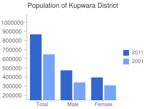
As of 2011 I census, Kupwara had a population of 8,70,354 with 474,190 males and 396,164 females. The total population of the District is 8.70354 lakh persons as per the census 2011 which stimated to have rises o 33.85 % approximately from census 2001. Population is mostly living in rural areas and only 1.04 lakh souls live in urban areas .as per census 2011 , district Kupwara is having population of 8.70 lakh souls which conistitutes 14.88 % of total population of the state . out of the total population of the district , Schedule caste are about 0.01 % , Schedule tribe are 8.08 % .
| Description | 2011 | 2011 |
|---|---|---|
| Male | 474,190 | 341,303 |
| Female | 396,164 | 309,090 |
| Total | 870,354 | 650,393 |
Religions in Kupwara
| Religions | Percentage |
|---|---|
| Muslims | 93 % |
| Hindus | 6 % |
| Sikhs | 0.7 % |
| Others | 0.3 % |
Population in Kupwara

Kupwara has an average literacy rate of 64.51%,above than the national average of 59.5%: male literacy is 64%, and female literacy is 41%.However the literacy has increased since last census. In Kupwara, 13% of the population is under 6 years of age. The sex ration is 835 females per 1000 males as per census 2011 in aggregate . District has a population growth rate of 34.62 percent during the decade 2001 to 2011. The biggest ethnic population is of Muslims and working force accounts for 32.67 of the population. The main occupation of the population is Agriculture.A majority of the people are Muslims while there is a small community of Sikhs in both Kupwara and Handwara tehsils. Kashmiris are the major ethnic group and speak the Kashmiri language .
| District Hospital | 01 |
|---|---|
| CHC/SDH | 07 |
| DTC | 01 |
| PHC | 31 |
| NTPHC | 23 |
| AD | 06 |
| SHC | 02 |
| Sub Centers | 203 (142 Old) (61 New) |
| MAC | 33 |
| Total Health Institutions | 307 |
| General Nursing | 01 |
| S. No | Category | Sanctioned Strength | In Position | Vacant |
|---|---|---|---|---|
| 1. | Sr. Consultant | 04 | 03 | 01 |
| 2. | Consultant | 56 | 20 | 36 |
| 3. | Medical Officers | 180 | 91 | 89 |
| 4. | Dental Surgeons | 42 | 22 | 20 |
| 5. | Administrative Posts | 14 | 13 | 01 |
| Total (1 to 5) | 296 | 149 | 147 | |
| 6 | Para Medics | 879 | 629 | 250 |
| 7 | Others | 532 | 367 | 165 |
| 8 | Drivers | 68 | 61 | 07 |
| Total (6 to 8) | 1479 | 1057 | 422 | |
| G. Total: | 1775 | 1206 | 569 | |