District Profile Srinagar
Srinagar is the largest city and the summer capital of the Indian administered state of Jammu and Kashmir. It lies in the Kashmir Valley on the banks of the Jhelum River, a tributary of the Indus, and Dal and Anchar lakes. The city is famous for its gardens, waterfronts and houseboats. It is also known for traditional Kashmiri handicrafts and dried fruits.
The city is located on both the sides of the Jhelum River, which is called Vyath in Kashmir. The river passes through the city and meanders through the valley, moving onward and deepening in the Dal Lake. The city is famous for its nine old bridges, connecting the two parts of the city.
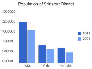
In 2011, Srinagar had population of 1,236,829 of which male and female were 651,124 and 585,705 respectively. In 2001 census, Srinagar had a population of 1,027,670 of which males were 558,353 and remaining 469,317 were females. Srinagar District population constituted 9.86 percent of total Maharashtra population. In 2001 census, this figure for Srinagar District was at 10.13 percent of Maharashtra population.

There was change of 20.35 percent in the population compared to population as per 2001. In the previous census of India 2001, Srinagar District recorded increase of 29.51 percent to its population compared to 1991.
| Description | 2011 | 2001 |
|---|---|---|
| Actual Population | 1,236,829 | 1,027,670 | Male | 651,124 | 558,353 | Female | 585,705 | 469,317 | Population Growth | 20.35% | 29.51% | Area Sq. Km | 1,979 | 1,979 | Density/km2 | 625 | 564 | Proportion to Jammu and Kashmir Population | 9.86% | 10.13% | Sex Ratio (Per 1000) | 900 | 841 | Child Sex Ratio (0-6 Age) | 865 | 865 | Average Literacy | 69.41 | 63.13 | Male Literacy | 76.25 | 72.56 | Female Literacy | 61.85 | 51.79 | Total Child Population (0-6 Age) | 158,300 | 158,300 | Male Population (0-6 Age) | 84,897 | 84,897 | Female Population (0-6 Age) | 73,403 | 73,403 | Literates | 748,584 | 0 | Male Literates | 431,746 | 0 | Female Literates | 316,838 | 0 | Child Proportion (0-6 Age) | 12.80% | 15.40% | Boys Proportion (0-6 Age) | 13.04% | 15.20% | Girls Proportion (0-6 Age) | 12.53% | 15.64% |

There are a number of lakes and swamps in and around the city. These include the Dal, the Nigeen, the Anchar, Khushal Sar, Gil Sar and Hokersar.
Hokersar is a wetland situated near Srinagar. Thousands of migratory birds come to Hokersar from Siberia and other regions in the winter season. Migratory birds from Siberia and Central Asia use wetlands in Kashmir as their transitory camps between September and October and again around spring. These wetlands play a vital role in sustaining a large population of wintering, staging and breeding birds.
Hokersar is 14 km (8.7 mi) north of Srinagar, and is a world class wetland spread over 13.75 km2 (5.31 sq mi) including lake and marshy area. It is the most accessible and well-known of Kashmir's wetlands which include Hygam, Shalibug and Mirgund. A record number of migratory birds have visited Hokersar in recent years.
Birds found in Hokersar—Migratory ducks and geese which include brahminy duck, tufted duck, gadwall, garganey, greylag goose, mallard, common merganser, northern pintail, common pochard, ferruginous pochard, red-crested pochard, ruddy shelduck, northern shoveller, common teal, and Eurasian wigeon.
Srinagar has a humid subtropical climate much cooler than what is found in much of the rest of India, due to its moderately high elevation and northerly position. The valley is surrounded by the Himalayas on all sides. Winters are cool, with daytime temperature averaging to 2.5 °C (36.5 °F), and drops below freezing point at night. Moderate to heavy snowfall occurs in winter and the highway connecting Srinagar with the rest of India faces frequent blockades due to icy roads and avalanches. Summers are warm with a July daytime average of 24.1 °C (75.4 °F). The average annual rainfall is around 720 millimetres (28 in). Spring is the wettest season while autumn is the driest. The highest temperature reliably recorded is 38.3 °C (100.9 °F) and the lowest is −20.0 °C (−4.0 °F).
As of 2011 census Srinagar urban agglomeration had 1,237820 population.[41] Both the city and the urban agglomeration has average literacy rate of approximately 70%. The child population of both the city and the urban agglomeration is approximately 12% of the total population. Males constituted 53.0% and females 47% of the population. The sex ratio in the city area is 888 females per 1000 males, whereas in the urban agglomeration it is 880 per 1,000. The predominant religion of Srinagar is Islam with 96% of the population being Muslim. Hindus constitute the second largest religious group representing 2.75% of the population. The remaining population constitutes Sikhs, Buddhist and Jains.
| S. No | Category | Total |
|---|---|---|
| 1 | District Hospital | 1 |
| 2 | Community Health Centre | 1 |
| 3 | Primary Health Centers | 7 |
| 4 | New Type PHC's | 33 |
| 5 | Urban PHC's | 26 |
| 6 | Urban Health Centers | 1 |
| 7 | Urban Health kiosks | 22 |
| 8 | Sub Centers | 34 |
| 9 | District TB Centre | 1 |
| 10 | Mini Maternity Centre | 4 |
| 11 | Leper Hospital | 1 |
| 12 | Trauma Hospital | 1 |
| Total | 132 |